Digitizing Prescribed Burns Permits with GIS
Reducing Bureaucratic Load for Prescribed Burns Authorizations in La Rioja
Until now, this activity required a complex administrative process, not only because of the large number of applications but also due to safety requirements, as it poses potential environmental risk that demands prior technical assessments.
In order to reduce the administrative workload and enable farmers to obtain their permits much faster, Vexiza has developed a new application for the Directorate General of Natural Environment and Landscape of La Rioja, which digitalizes every step of the process.
Digitizing the burn permit management system
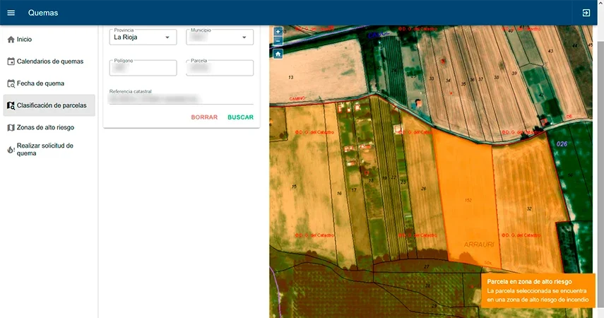
The brand new Quemas La Rioja app systematically assesses the risk level of each plot using several risk markers embedded in a map layer, such as the proximity to forested areas.
If the plots selected by the user requesting the procedure are located in a low-risk area, an automatic permit is issued along with a digital copy to the respective municipality, allowing the burn to be carried out on a specific date.
On the contrary, if the risk is high, the application immediately notifies the forest agents responsible for that geographical area, so they can individually review the request and authorize it through the same channel.
As a result, we optimize the management and review of applications, centralizing the process and minimizing the unnecessary bureaucratic burden on municipal staff.
Additionally, the app provides easy access to an updated digital log of prescribed burns, aiding in the prevention of false alarms and the unnecessary mobilization of fire response teams.
GIS viewer customized for each user’s specific needs
The app is designed to be user-friendly and easy to use, ensuring that even users with minimal digital skills can avoid unnecessary trips to complete paperwork.
The process is carried out in just a few steps, making it easy for anyone to manage their burn applications quickly. Users can locate the parcel they wish to apply for by using the geographic viewer and clicking on it, or they can simply input the cadastral reference.
Forest agents, on the other hand, have access to an interface that organizes and clearly displays all requests awaiting approval. They also have access to a calendar detailing the approved burns in high-risk zones, allowing them to oversee the entire process and effectively coordinate actions with other entities if necessary.
Finally, anyone, without requiring registration, can access the application to find out the approved dates for conducting burns in a region, municipality or parcel, as well as to learn about areas at high risk of fire.
Such transparency guarantees that information is readily accessible to citizens, enabling the proactive planning of burns in advance of the application process and facilitating more efficient management of agricultural and forestry activities.
Curious about innovative ways to digitize your work processes through GIS? Reach out to us on our contact page.
Technologies and technical details
Java
Oracle