Retechfor: Building the Future of Wildfire Management
In order to reinforce this response capacity, the Retechfor project is focused on advancing the digitalization of the forestry sector and encouraging the use of cutting-edge technology in wildfire response operations. As part of this initiative, Vexiza contributes as a technology development partner within a large consortium of universities, research institutions, cross-sector organizations, and businesses.
Our work is built upon three core lines: strengthening information systems for wildfire management, fostering tools for public communication on prevention and emergency situations, and developing new innovative solutions that position Castilla y León at the forefront of applying technologies such as artificial intelligence in the forestry sector.
Upgrading Operational Wildfire Management
The Castilla y León wildfire response framework, INFOCAL, already has a wide range of digital tools that enable resource coordination and support decision-making during emergencies. However, the growing complexity of wildfires, which are becoming increasingly intense and harder to predict, makes it necessary to continue evolving these systems.
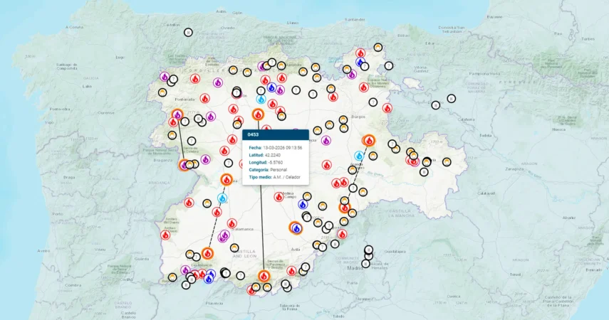
The project places geospatial information at the core of coordination and preparedness for wildfire response. Its initiatives include improving inventory and resource management, creating systems to register and visualize defense and critical infrastructure, and strengthening knowledge management platforms and personnel training.
Making Wildfire Operations More Accessible to the Citizens
INFORCYL is already firmly established as the leading public information platform for wildfires in the region. It serves as a channel to communicate the actions carried out by the INFOCAL operation, delivering reliable and up-to-date information on active incidents.
However, as its impact grows, so does the public’s demand for clear and accessible information about wildfires. To address this, we are reinforcing INFORCYL’s capacity to communicate emergency situations in a more detailed and comprehensible way. Enhancements include the communication of alert and alarm situations, the integration of meteorological information, and the real-time dissemination of civil protection warnings.
In addition, a dedicated space has been created for media outlets, facilitating their role in sharing critical information. This includes a multimedia repository and a historical archive of major wildfires, enabling easy access to visual materials and documentation related to the most significant fires recorded in the region.
Boosting technological innovation in the forestry sector
The final key pillar focuses on developing innovative tools that provide new, high-value information to emergency services. To this end, we contribute R&D initiatives aimed at optimizing wildfire monitoring, prediction, and response from new perspectives.
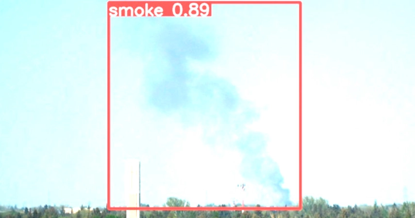
Key developments include an AI-powered automatic smoke detection system that continuously monitors the forest camera network in real time. It ensures reliable alerts through a robust training dataset and a dual-validation process that filters out false positives caused by mist, clouds, or glare
In parallel, we are developing wildfire risk and severity analysis algorithms based on multispectral imagery and AI techniques, along with new fire spread simulators grounded in more rigorous scientific standards.
Moreover, new risk indices are being created to provide a more holistic evaluation of wildfire danger. These indices take into account both atmospheric conditions that promote fire spread and terrain features that complicate suppression. This approach not only predicts where fires are more likely to spread, but also identifies areas where they will be harder and more dangerous to contain, enabling more effective resource allocation.
Overall, these innovative solutions are transforming how wildfires are predicted, detected, and managed, positioning Retechfor and Castilla y León at the forefront of applying GIS and advanced technologies to emergency management.