Open Access Real-Time Data on Wildfires
INFORCYL: A GIS Platform for Transparency in Wildfire Emergency Management
Yet, despite their relevance, the ever-changing nature of fires makes it difficult to communicate the scale of the efforts undertaken by the thousands of individuals involved in firefighting operations.
To enhance public understanding of forest fires, Vexiza has developed INFORCYL, an innovative GIS platform for the Junta de Castilla y León that provides real-time data on wildfires and all related operations to both the media and citizens.
GIS for Public Awareness on Forest Fires
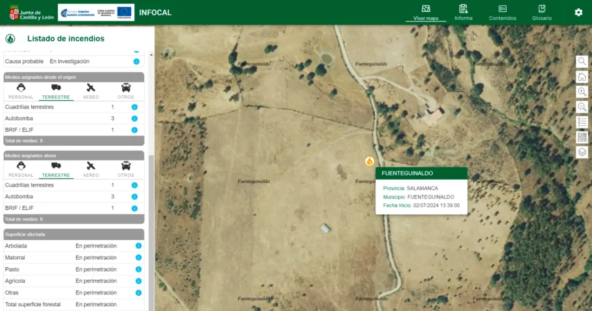
INFORCYL is a GIS-based web application that provides a detailed map of Castilla y León, and integrated with the same emergency management tool used by the regional and local coordination centers
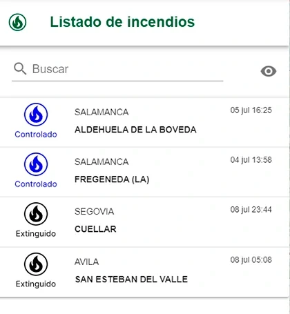
From this spatial and alphanumeric information, it extracts all active forest fire emergencies and displays them on the map, making their exact location accessible to everyone. This provides a clear overview of the wildfires taking place in the region, indicating as well whether they are active, controlled, or have just been extinguished.
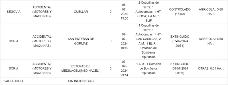
Clicking on any fire allows users to immediately see all personnel assigned to extinguishing it, both from ground and aerial units. The information also includes the time the fire was declared and its severity level according to the standards of the Civil Protection Emergency Plan
Working with real-time information, the platform also presents details such as the probable cause of the fire and the type of forest surface affected as the investigation advances.
Comprehensive Firefighting Information
Given that a primary goal is to enhance the communication of information on wildfires, another key aspect of INFORCYL is accessibility.
Because of the complexity of forest fires, along with the operations, organization, and regulatory aspects linked to them, every piece of data shown on the screen comes with an explanatory text to ensure it is comprehensible for the user.
They are intended to clarify technical terms and the roles of the involved personnel, making it easier to understand ongoing operations. For instance, they offer information about the brigades and resources deployed, helping the user comprehend the logistics and response capacity of the tactics used against the fire.
The data also include definitions of different vegetation types and their importance in the potential spread of the fire. This enables everyone, regardless of their technical knowledge, to grasp the seriousness of any given situation.
Lastly, the platform allows users to download provisional reports on the causes and areas affected by the fires, which is the same information that technicians in the command center use, thus democratizing access to the most reliable information on wildfires.
Technologies and technical details
Java
Oracle